GPS Monitoring of Agricultural Machinery and Calculation of Completed Hectares
16.10 2025
Modern agriculture demands precision and transparency at all stages of production. In the era of digital transformation, the success of an agricultural enterprise directly depends on its ability to effectively manage resources, minimize losses, and optimize every process. One of the tools for achieving these goals is the innovative "Technique Tracks" module within the agricultural machinery monitoring system, developed by the Soft.Farm team. This is not just GPS monitoring; it is a comprehensive technological solution that provides full control and analysis of field operations.
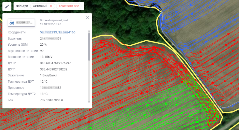
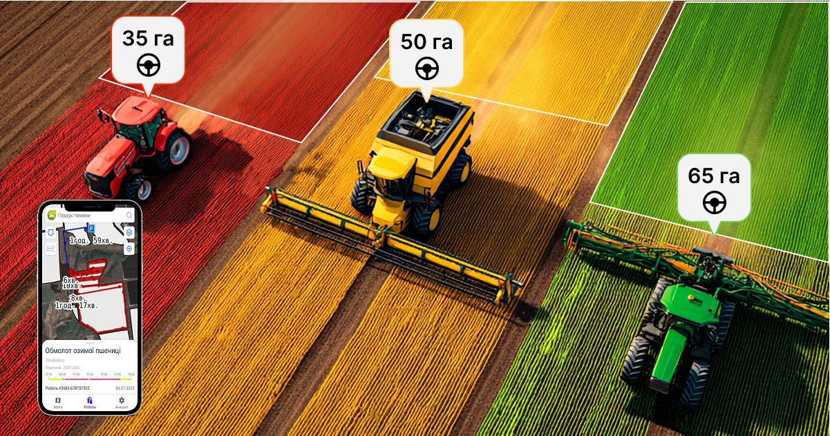
The "Technique Tracks" module enables agricultural enterprises to track the location and operation of farm machinery in real time, accurately calculate treated hectares, and optimize production processes. It is designed to transform machinery movement data into valuable information for making informed management decisions. This data forms the basis of the system's operation; we receive it from the largest GPS monitoring operators, including the Wialon provider and others from the available list. The data includes not only the history of machinery movement and information about the start/completion of work, but also more detailed information, such as coordinates and the exact route of movement, signals from equipment sensors installed on the machinery, the GSM signal level—which allows assessment of communication quality, and the volume of remaining fuel in the tanks, which is critically important for cost control. The received information is sent to our own server, where it is processed using internal advanced algorithms. This ensures high-speed processing and reliability of the system, allowing up-to-date data to be received without delay.

Understanding that not all machinery can be equipped with GPS systems, Soft.Farm offers a solution to ensure maximum coverage and convenience. For cases where machinery is not fitted with a stationary GPS tracker (for example, temporary machinery, rented units, or contractor equipment), the "GPS.RED" mobile application can be used. After its installation, any smartphone transforms into a full-fledged tracking device. The application transmits data directly to the server, ensuring the availability of the monitoring system even without the physical installation of specialized hardware. This is an ideal solution for rapid deployment and control of any unit of machinery.

One of the most significant advantages of the new module is its unique algorithm for analyzing telematics data. It is capable of automatically separating active fieldwork from movements between plots, meaning it divides tracks into "work" and "transit" (or "relocation"). This approach allows for the most accurate calculation of actually completed hectares, taking into account the set operating width of the implement, and helps to exclude untreated areas and overlaps, which often occur due to complex logistics, uneven terrain, or multiple entries into the same field. It also prevents duplication and inaccuracies in calculations, ensuring reliable data even in the most challenging conditions. Thanks to this level of detail, it is possible not only to monitor the volume of work but also to analyze the efficiency of fuel and time usage.

Upon completion of all agro-operations within a specific geofence, the field can be "closed" in the system. This means that the area is no longer subject to change, and all collected data pertaining to it is locked. In this scenario, the calculation of closed hectares achieves ideal accuracy, and the user receives fully verified data, ready for generating reports, analyzing efficiency, settling accounts with contractors, or maintaining agronomic documentation.
By utilizing GPS monitoring within the Soft.Farm system, you receive a comprehensive set of advantages that transform agribusiness management:
- Accurate Real-Time Machinery Tracking: Full control over the location and status of every unit of machinery.
- Transparent and Reliable Calculation of Completed Work: Always know how many hectares have been treated, where, and by whom.
- Proprietary Server and Data Collection Software: A guarantee of security, speed, and reliability in storing and processing information.
- Integration Capability with Any GPS Devices: Flexibility in using existing equipment.
- Mobile Application Support for Employees and Contractors: Expanding monitoring capabilities to all machinery, regardless of its equipment level.
- Fuel Cost Optimization: Detection of unauthorized trips ("side trips"), control over refueling, and fuel consumption.
- Increased Discipline Among Operators: Knowing their work is being tracked, drivers become more accountable.
- Efficiency Analysis and Planning: The received data serves as the foundation for improving logistics, routing, and planning future operations.
In conclusion, "Technique Tracks" from Soft.Farm is not just GPS monitoring. It is a full-fledged field operations management tool that allows for controlling machinery, analyzing efficiency, and making decisions based on accurate data. The use of our services enables you to reach a new level of agricultural machinery management—with full digitalization, up-to-date data, and high accounting precision. Manage your machinery at a modern level—simply, accurately, and conveniently with Soft.Farm.
Back to news list