Satellite monitoring of vegetative indices NDVI, EVI, GNDVI, CVI
02.03 2020
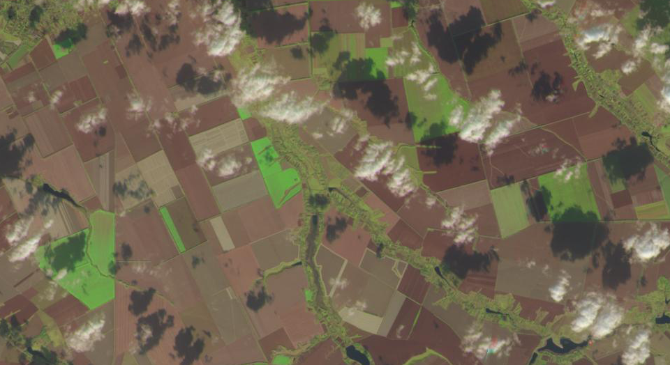
For operational monitoring of the state of crops, the technology for monitoring changes in the vegetation index, which was obtained by analyzing satellite images, has long been used.The spectral reflectivity of vegetation is characterized by large differences in the reflection of radiation of different wavelengths; therefore, knowledge of the relationship between the structure and state of vegetation and its spectral reflectivity allows the use of satellite images to map and identify types of vegetation and their states.
To work with spectral information, often appeal to creating «index» images, which are based on a combination of brightness values in certain channels, informative for highlighting the object under study, and calculating «spectral index» based on these values. The resulting images correspond to the index value in each pixel, which allows you to select the object under study or evaluate its condition. The spectral indices used to study and assess the state of vegetation are called vegetation indices.

The main advantage of vegetation indices is the ease of obtaining and a wide range of tasks to be solved with their help. So, NDVI is often used as one of the tools for more complex types of analysis, which may result in maps of agricultural land productivity, maps of landscapes and natural zones, and multi-season images allows to obtain quantitative estimates of the predicted yield of various crops, to note the features of the seasonal development of crops violations, assess the quality of agricultural work, carry out planning, etc. Thanks to vegetation indices, it becomes possible not only to wire be mapping vegetation, but also to identify the areas covered and uncovered vegetation density estimate, germination, plant state, and using regular monitoring to observe the development of processes in dynamics.

For a more detailed study of the factors influencing the development of culture, the Soft.Farm functional has the ability to analyze not only NDVI, but also other vegetation indices calculated by the program in accordance with the formula and using wide-range spectral data. These are the indexes EVI (Enhanced Vegetation Index), GNDVI (Green Normalized Difference Vegetation Index), CVI (Chlorophyll Vegetation Index) and True Color, which characterize various qualitative and quantitative indicators depending on the needs of a particular enterprise.

Monitoring of land in dynamic implies data collection, which is carried out at some intervals, and plays an important role in the field of agriculture. Thus, the great advantage of using satellite imagery is their retrospectiveness. If the desired site is in the «field of view» of the satellite, you can get the history of such a site over the past few years, which will indicate the dynamics of the development of biomass in certain fields, as well as the most and least productive zones.
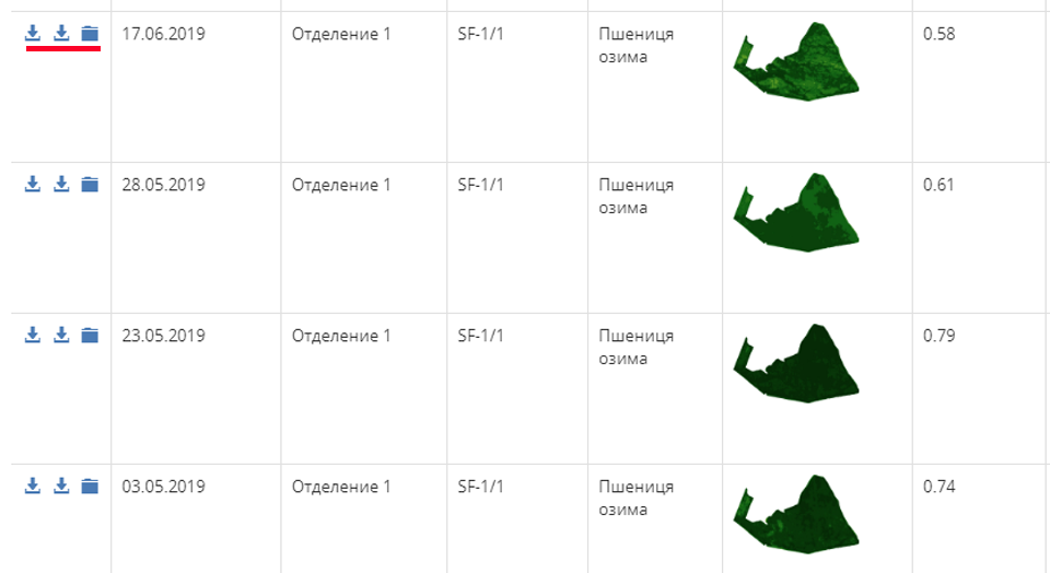
Satellite images in Soft.Farm are easy to collect and compare with each other. At the same time, it is not necessary to subscribe for the whole year and for all fields of the enterprise, since images can be ordered only at sites of interest. On the Dashboard, in the «NDVI — Subscriptions» item, just select the desired field and date. Payment for images takes place from the account in your account, therefore it is better to replenish it in advance in any convenient way. As a result, you get only the pictures you need, which you can simply view in a web service or download as KML or PDF files. Then they can be downloaded or transferred to any other program or system, including Google Earth. Downloading detailed satellite images is available in the «Documents — NDVI Reports» menu, where they can be filtered by the date of the image, department or field, so you won’t have to spend a lot of time searching for the necessary information.

The functionality of the Soft.Farm web service is constantly being improved and becomes more convenient for users. In addition to automatically calculating areas with different vegetation and the ability to group images, you can determine areas for applying larger fertilizer norms and creating electronic task maps for equipment, and then use these cards for differential application. Also now you do not need to go into the program daily and check the appearance of new images. The system will inform you of the download of a new satellite image by a letter to the email, specified during registration.
At present, satellite monitoring is a powerful and perspective tool that can be the basis for a wide variety of assessments of the condition of crops, from taking into account areas of damaged crops (pests, diseases, physical factors, etc.) to assessing weediness, morbidity, and predicting crop yields. Register in the Soft.Farm system and observe the development of vegetation in your fields today.

Back to news list