Measurement and precise marking of fields for drawing up an electronic map of an agricultural enterprise
13.01 2021
Reliable data on the area of cultivated fields is the basis for effective land bank management. They are important not only for high-quality cadastral registration, but also for determining the amount of seeds, fertilizers, plant protection products, fuel and other resources used in field work. Knowing the actual cultivated area makes it possible to correctly calculate the amount of costs and avoid unjustified costs even at the planning stage.

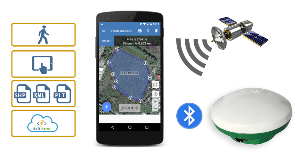
Today, the simplest and most affordable method for measuring the area of a land plot is to use a mobile device with the Soft.Farm application «GPS. Fields. Area Measurement». With it you can create fields and measure their area in different ways. For example, you can mark control points on the map and save the resulting field contour without leaving your office. You can also download ready-made files in KML, SHP, PLT formats, or enter the existing geographic coordinates of the control points manually. We have expanded the functionality of the mobile application and its use has become even more convenient. Now each added contour of the field can be painted in any color at the discretion of the user and in this color he can see it on the map. It also became possible to add a text note to the saved fields and view or edit it at the right time. These functions will help not only when maintaining cadastral records, but also when planning crops, forming crop rotation schemes, identifying problem areas, etc.

To measure the area of the field on the ground, there is a track recording function. With its help, you can follow the perimeter of the land, using a smartphone or tablet as a GPS receiver, and then save the track in KML format for further exporting the file. For more accurate measurements, it is possible to connect external antennas via Bluetooth and thanks to them receive GNSS or RTK signals. Convenient and understandable functionality of the application allows you to get all the necessary data on the route traveled and use them in your work. To find out the distance to the desired field or other object, we added a distance measurement function. It makes it possible to measure both between specified points on the map, and from any point to the current location, determined by the GPS signal of a mobile device. Thanks to it, you can plan the consumption of time and fuel, optimize the location of fields and the routes of equipment.

Edits can be easily made to electronic maps of fields. If you change the configuration of the field, you can save its new outline and transfer it using instant messengers. Download the mobile application «GPS. Fields. Area Measurement» and digitize your fields with it absolutely free.
Back to news list